
From the Black Sea to the Baltic: Russia’s Grain Trade Finds New Routes
Russian companies are repurposing Baltic and Arctic terminals to export grain traditionally shipped through the Black Sea. As attacks disrupt
Russian companies are repurposing Baltic and Arctic terminals to export grain traditionally shipped through the Black Sea. As attacks disrupt

From Churchill and Nuuk to Murmansk, Arkhangelsk and Kamchatka, a network of ports, railways and maritime gateways is beginning to reshape the geography of Arctic trade.
Georgia's $7 billion transport ambitions and new investment across the Caspian could reshape trade between Asia and Europe. But expanding railways and ports is only part of the challenge. The real test is whether the entire corridor can move cargo reliably, competitively and at scale.
From Churchill and Nuuk to Murmansk, Arkhangelsk and Kamchatka, a network of ports, railways and maritime gateways is beginning to reshape the geography of Arctic trade.

For years, the commercial debate around Arctic shipping has revolved around a deceptively simple question: could a warming Arctic eventually provide a viable alternative to the established maritime routes connecting Asia, Europe and North America?
The Northern Sea Route along Russia’s Arctic coastline has usually occupied the centre of that discussion, with Canada’s Northwest Passage treated as the less-developed counterpart. Both have routinely been measured against the Suez Canal through calculations of distance, sailing time, ice conditions and the theoretical savings available to ships moving between Asian and European markets.
That framing is becoming too narrow.
A series of developments across Russia, Canada and Greenland points toward a different Arctic story, one in which some of the most consequential changes are taking place not at sea, but ashore. Ports are being expanded, dormant gateways are being reactivated, railways are being proposed, transshipment hubs are moving forward and new institutional links are beginning to form between Arctic port operators.
Russia is discussing an Arctic transport programme potentially costing around $116 billion. China is becoming more directly involved in Russian Arctic logistics. Arkhangelsk is moving forward with plans for a deepwater port. A China-linked port and rail corridor is being advanced in Yakutia. Another large transshipment project is taking shape in Kamchatka.
Across the Arctic, meanwhile, the Port of Nuuk has entered a cooperation agreement with the developers of two proposed Nunavut deepwater ports, while Canada’s Port of Churchill has returned to grain exports after six years.
None of these developments alone transforms global shipping.
Together, however, they point toward something structurally more important: the Arctic is gradually acquiring the infrastructure of a transport system.
And that changes the question.
The issue is no longer simply whether ships can cross Arctic waters. It is whether enough ports, railways, roads, transshipment facilities, industrial projects and logistics services can be connected to make those voyages commercially repeatable.
A navigable route is not the same thing as a functioning trade corridor.
That distinction matters particularly in the Arctic. A ship may technically be capable of sailing between two points, but regular commercial shipping requires considerably more than open water and an ice-capable hull. It requires cargo volumes, storage, communications, hydrographic information, search-and-rescue capability, bunkering, repair facilities, predictable regulation, insurance and sufficient maritime services to keep vessels operating.
Most importantly, ports need hinterlands.
A deepwater terminal without a railway, road, pipeline or substantial cargo base may have strategic value, but it does not automatically become a major commercial gateway. A railway leading to the Arctic coast is similarly of limited value unless suitable ports and vessels are available to receive the cargo when it arrives.
Russia’s evolving Arctic strategy increasingly acknowledges precisely this problem.
Moscow has begun placing greater emphasis on what it calls the Trans-Arctic Transport Corridor, rather than treating the Northern Sea Route simply as a maritime lane along the country’s northern coastline. According to recent reporting on Russia’s Arctic shipping ambitions, Rosatom chief executive Alexey Likhachev has estimated that around RUB10 trillion — approximately $116 billion — could be needed through 2035 to build out the wider system.
The significance of that figure lies less in its headline size than in what it is intended to finance.
The programme extends across ports, railway connections, inland waterways, logistics infrastructure, icebreakers and a substantially larger fleet of ice-class merchant ships. Russia’s baseline scenario reportedly envisages Arctic cargo volumes rising from roughly 37 million tonnes today to between 110 million and 150 million tonnes by 2035.
That is a very different proposition from asking whether an individual vessel can shave days off an Asia-Europe voyage by sailing north rather than through Suez.
It is an attempt to create an integrated logistics system.
That distinction has already begun to appear in commercial shipping. As argued previously in China’s Arctic Shipping Ambition Is Moving From Experiment to Network, the important threshold is not whether a single ship can make a successful Arctic passage. It is whether a service can be repeated often enough that shippers begin planning around it. China-linked Sealegend Shipping’s scheduled Northern Sea Route programme for 2026 represents precisely that transition, with eight planned sailings between China and northern Europe during the navigation season. The latest wave of infrastructure projects pushes that argument a stage further.
A repeated shipping service creates a network.
Ports, railways, transshipment facilities and hinterland connections turn that network into a corridor.
Russia begins that process with advantages that no other Arctic state possesses at comparable scale. It has the world’s longest Arctic coastline, an established chain of northern ports, substantial mineral and hydrocarbon production, extensive inland transport networks, decades of experience operating in severe ice conditions and the world’s largest icebreaker fleet.
The existing Russian Arctic port network already includes gateways performing very different roles, from resource-export terminals to major logistics centres. Murmansk is particularly important because its Barents Sea location gives Russia an ice-free western Arctic gateway connected both to the North Atlantic and to the country’s wider rail and industrial system.
That existing infrastructure gives Moscow something other Arctic states do not yet have: a foundation on which to construct a larger corridor.
China is becoming increasingly important to that calculation.
A Chinese container ship recently docked at Murmansk after transiting the Northern Sea Route, an arrival that Russian Foreign Minister Sergey Lavrov described as representing a new phase in the development of Arctic transport. Reporting on the voyage placed it within the wider expansion of Russia-China cooperation in Arctic logistics and shipping.
The event should not be overstated. One vessel does not create a new global trading system, and the Northern Sea Route remains subject to serious seasonal, technical, financial and geopolitical constraints.
But China’s role is changing.
For much of the past decade, Beijing could reasonably be described primarily as a customer of the Russian Arctic — purchasing energy, participating selectively in large resource projects and developing its own polar capability. Increasingly, however, China is becoming involved in the transport architecture that moves those commodities.
That is a more consequential development.
The distinction is between using the Arctic and helping build the logistics system around it.
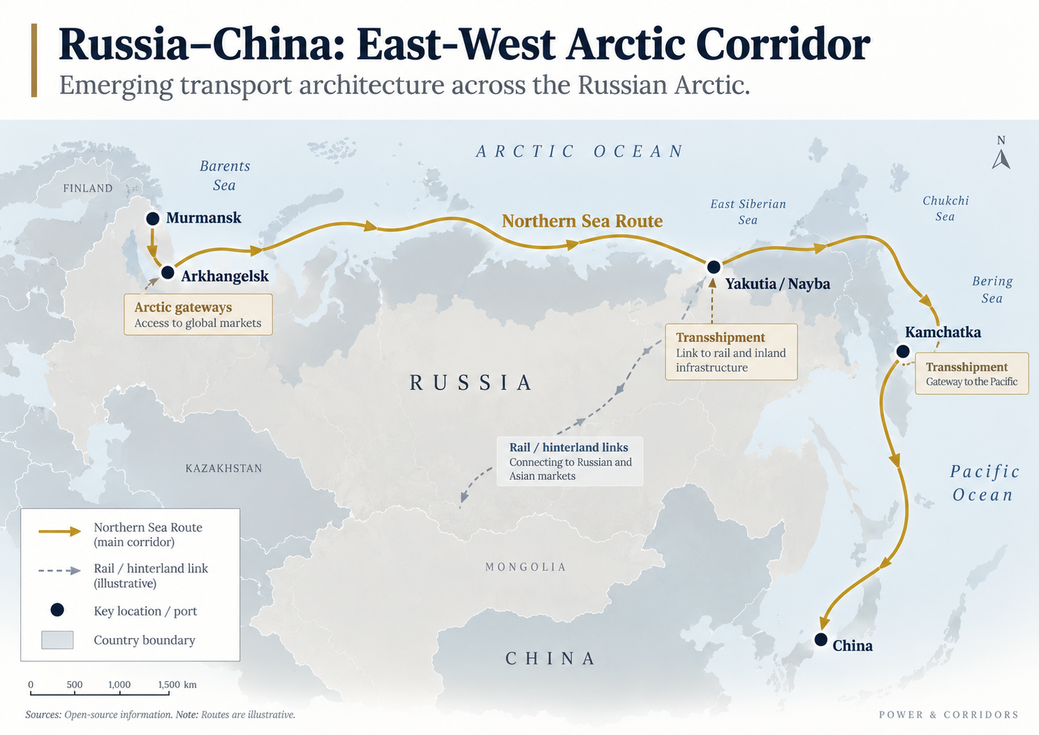
The emerging Russia-China Arctic relationship can be seen particularly clearly in the projects now taking shape at Arkhangelsk and in Yakutia.
Russia is moving ahead with plans for a new deepwater port complex at Arkhangelsk, with an indicative completion target of 2032. The planned development includes container handling facilities, mineral-fertiliser capacity, terminals for coal, petroleum coke and general cargo, as well as bunkering infrastructure. Those facilities matter, but the larger significance of Arkhangelsk lies in what sits behind the port.
Arkhangelsk connects Arctic water with Russia’s continental rail system. Cargo arriving from the interior can be transferred into maritime transport and moved eastward through the Arctic. Conversely, cargo arriving by sea can enter Russia’s internal logistics network.
It is the interface between land and water that creates the corridor.
The proposed development at Nayba in Yakutia makes this relationship even clearer.
The Mohe-Nayba project would combine a deepwater Arctic port with an enormous rail-building programme extending toward the Russian-Chinese border and across Russia’s Far East. Plans reportedly envisage approximately 1,300 kilometres of new railway linking Nizhny Bestyakh with Nayba and a further roughly 1,670 kilometres extending toward Magadan.
The project remains highly ambitious. Financing is not complete, commissioning remains some distance away and the economics of constructing thousands of kilometres of railway through difficult terrain will be challenging.
Those uncertainties should not be understated.
The Arctic has a long history of infrastructure announcements that prove difficult to finance, construct or operate commercially. Severe weather, permafrost, limited populations, environmental constraints and enormous distances can turn apparently attractive projects into extremely expensive ones.
Yet the strategic logic behind Nayba is important regardless of whether every element is eventually completed.
The concept effectively attempts to draw China’s industrial geography northward toward Arctic water.
Instead of treating the Northern Sea Route as something ships reach after navigating from existing Pacific ports, the proposed corridor would connect Chinese and Russian inland transport networks much more directly to the Arctic coastline.
That is a significant change in how the route is being imagined.
The Arctic becomes not simply a sea passage running above Russia, but the northern edge of a much larger Eurasian transport system.

Kamchatka addresses another structural problem.
Ice-capable vessels are expensive to build and operate. Requiring specialised ships to complete entire international voyages would make large-scale Arctic services considerably harder to commercialise. Russia’s proposed roughly $1.6 billion Kamchatka transshipment hub offers one potential solution.
The basic logic resembles a hub-and-spoke model adapted to polar conditions.
Specialised ice-capable vessels operate within the more difficult Arctic section of the journey. At the edge of that system, cargo can be transferred to conventional ships operating across ordinary international routes.
That division matters because it potentially reduces the amount of expensive specialised tonnage needed to sustain Arctic trade.
Taken together, Murmansk, Arkhangelsk, Nayba and Kamchatka start to reveal the shape of Russia’s larger ambition. The objective is not simply to have a navigable Northern Sea Route. It is to build gateways at both ends, connect those gateways with inland transport, feed them with sufficient cargo and create specialised transshipment infrastructure capable of linking Arctic shipping to the rest of the maritime system.
The route becomes valuable because of the network around it.
Nothing comparable yet exists across the Canadian and Greenlandic Arctic.
The scale is smaller, infrastructure is thinner, investment is more fragmented, population centres are widely separated and much of the proposed port capacity remains at an early stage.
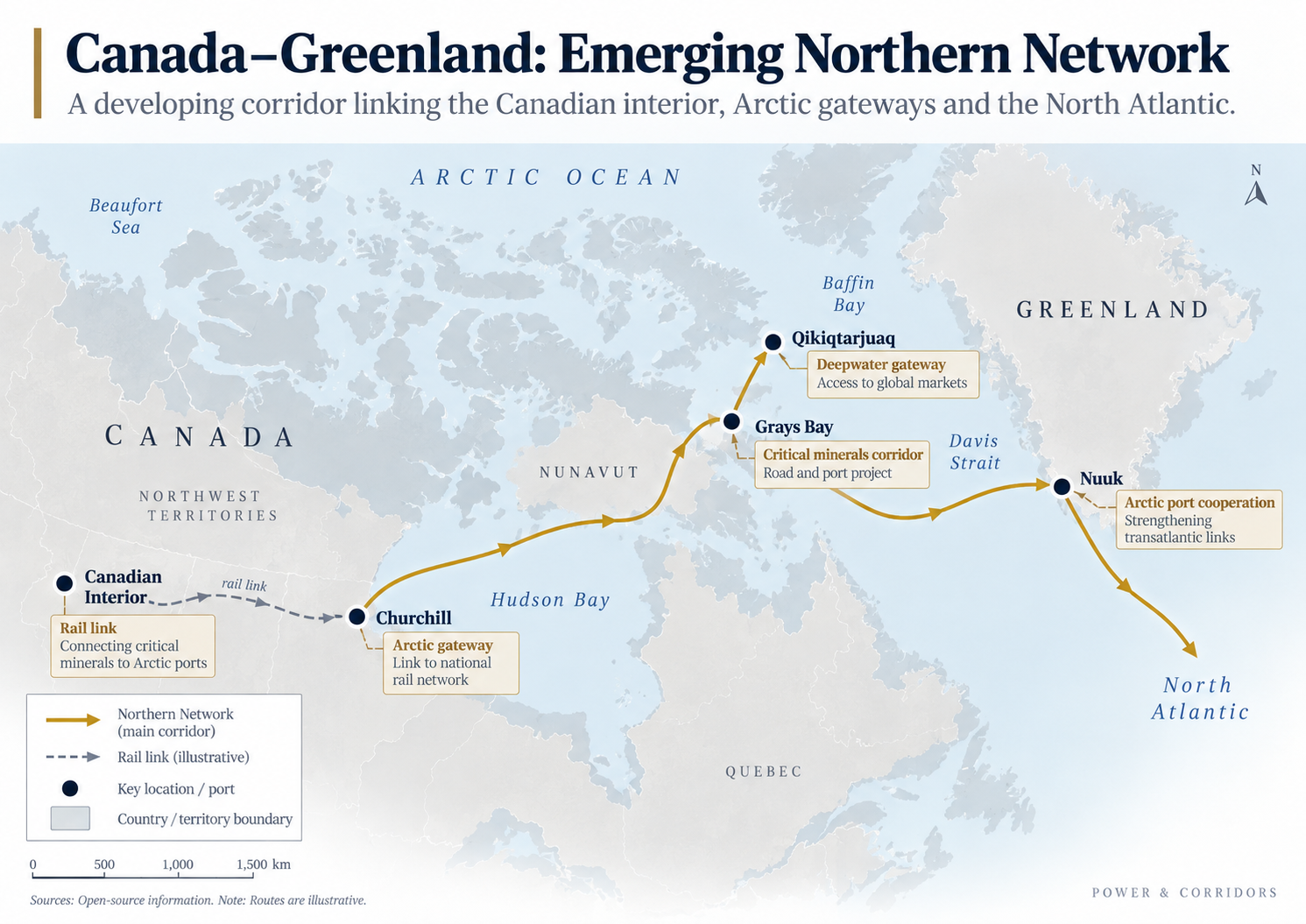
But developments around Nuuk, Qikiqtarjuaq, Grays Bay and Churchill suggest that a different type of Arctic network is beginning to take shape.
The recent agreement involving Greenland and Nunavut is particularly interesting because it is less about one new port than about connecting several emerging gateways.
Sikuki Nuuk Harbour, operator of the Port of Nuuk, has entered into a cooperation arrangement with Qikiqtaaluk AEDC, which is developing the proposed Qikiqtarjuaq Deep Sea Port, and West Kitikmeot Resources Corp, which is advancing the Grays Bay Road and Port project.
According to the announcement reported by Canadian Defence Review, the agreement covers areas including port operations, logistics, vessel support, emergency response, infrastructure planning and supply-chain development.
On the surface, this may appear modest compared with Russia’s multibillion-dollar infrastructure ambitions.
Geographically, however, it is important.
Nuuk is already an established commercial gateway on Greenland’s west coast. Qikiqtarjuaq sits on eastern Baffin Island near the approaches to the Northwest Passage. Grays Bay lies much farther west and is designed as something more than a port: a combined road-and-port project connecting mineral deposits in the Kitikmeot region with Arctic tidewater.
Maritime reporting on the agreement notes that the proposed Qikiqtarjuaq facility would support fisheries, northern resupply, crew changes and other marine services, while Grays Bay would combine a deepwater port with an approximately 230-kilometre all-season road.
The significance is not that these projects suddenly create a North American competitor to Russia’s Northern Sea Route.
They do not.
The significance is that individual Arctic facilities are beginning to think as a network.
Ports can share operational experience. Emergency-response capacity can be coordinated. Supply chains can be linked. Vessel services can become more predictable. Infrastructure planning can begin to reflect what is happening across the wider Arctic rather than simply within one jurisdiction.
That is how maritime systems begin to acquire depth.
Greenland is particularly important within this geography.
As explored previously in So You Want to Own Greenland?, Greenland sits at the intersection of North Atlantic security, Arctic access, critical minerals, sovereignty and great-power competition. Its significance is not simply that it occupies a large space on the map. It lies between the Canadian Arctic, the North Atlantic and the European strategic environment, giving it potential importance as an economic and logistical connector as well as a security geography.
Nuuk’s relationship with Nunavut therefore adds another layer to an already important position.
It introduces the possibility of increasing east-west Arctic connectivity across Davis Strait.
That matters because much of the Canadian Arctic has historically been characterised by north-south dependence. Communities, mines and military facilities are supplied from southern Canada. Greenland similarly connects southward toward Denmark and Europe.
Growing port relationships across the Arctic begin changing that orientation.
A system that once consisted largely of isolated northern endpoints starts developing lateral connections between them.
Churchill presents a different model again.
Unlike many proposed Arctic port developments, Churchill already possesses the element that is often hardest to create: a railway linking the port directly with a large continental economic hinterland.
Its challenge has instead been maintaining the infrastructure and generating sufficient cargo to make regular commercial use sustainable.
That makes the recent return of grain exports significant.
The first grain shipment from Churchill in six years reportedly involved roughly 30,000 tonnes of Canadian durum wheat destined for Europe.
In global grain-trading terms, that cargo is modest.
The corridor behind it is more interesting:
That chain illustrates why Arctic commercial development does not necessarily depend on creating an entirely new Asia-Europe maritime route.
Churchill already reaches deep into one of the world’s major agricultural and resource-producing economies.
Its value lies in connecting that productive hinterland to Hudson Bay.
The port is also increasingly discussed in relation to potash, minerals, community resupply and other northern cargoes. In other words, grain does not have to carry the entire commercial case by itself.
That diversification is important because successful ports rarely survive on geography alone. They need cargo streams that complement one another across seasons and markets.
Churchill also demonstrates how different the North American model may ultimately look from Russia’s.
Russia is primarily building longitudinally along its Arctic coastline, linking western ports, Siberian resources and Pacific gateways.
Canada’s geography encourages something more vertical.
Cargo moves north from established agricultural, mining and industrial regions toward Arctic water.
Greenland and Nunavut then introduce the possibility of lateral links across the northern maritime space.
The emerging network may therefore look less like a single shipping lane and more like a series of connected spokes reaching into the Arctic from different directions.
The mineral dimension makes this much more than a shipping story.
Remote mineral deposits do not become strategically useful simply because they exist. They need energy, roads, railways, ports, workers, processing capacity and reliable access to markets.
Transport infrastructure therefore determines which resources can actually become part of a supply chain.
Grays Bay illustrates the relationship particularly well.
Its proposed all-season road would connect mineral deposits in Canada’s interior with a deepwater Arctic port. Copper, zinc and potentially other critical minerals would gain a maritime export pathway that does not presently exist at comparable scale.
The sequence is straightforward:
Every missing element reduces the commercial value of the resource.
The same principle can be applied to Russia’s Arctic strategy. Nayba is potentially valuable because railway infrastructure would connect the port with inland cargo. Arkhangelsk matters because it connects the Russian transport network with Arctic water. Murmansk derives its importance partly from the extensive infrastructure behind it. Kamchatka could become valuable because it connects specialised Arctic shipping with conventional global shipping.
Ports are therefore not simply pieces of maritime infrastructure.
They are conversion points.
They convert inland geography into maritime access.
That gives them importance far beyond the waterfront.
It also explains why critical-mineral competition increasingly becomes a corridor competition.
States may identify the same categories of strategic resources — copper, nickel, zinc, rare earths and other minerals — but the resource that can reach a port reliably will usually have greater geopolitical and commercial value than the resource stranded hundreds of kilometres from transport infrastructure.
This relationship has particular significance in the Arctic, where distance magnifies every weakness in the logistics chain.
There is another reason Arctic ports matter.
Commercial infrastructure and strategic presence often overlap.
A functioning port supports coast guards, government vessels, research ships and potentially naval operations. It creates fuel and storage capacity. It helps sustain local communities. It supports search and rescue. It allows crews to change, vessels to shelter and equipment to be repaired.
It also generates maritime activity in places where government presence has historically been thin.
For Canada, this has obvious sovereignty implications.
Canadian governments have long emphasised Arctic sovereignty, yet sovereignty becomes far more meaningful when it is supported by infrastructure capable of sustaining people, vessels and economic activity.
Roads, ports, airfields, communications systems and icebreakers turn geographic claims into operational presence.
That does not mean projects such as Grays Bay or Qikiqtarjuaq should be reduced to military infrastructure. Their commercial, community and Inuit-development dimensions are central to their purpose.
But infrastructure has multiple uses.
A port built for mines or resupply can also support emergency response and government operations. A road serving industry changes access to previously isolated territory. More regular shipping improves maritime awareness. Greater commercial activity increases the number of vessels, operators and services capable of functioning in the region.
Russia has long understood that relationship between economic development and Arctic presence.
Ports, industrial settlements, energy projects, shipping and state capacity reinforce one another.
Canada and Greenland operate within very different political and economic systems, but the underlying geographic reality remains similar: northern presence is expensive, and infrastructure determines how sustainable that presence becomes.
This is where the conventional comparison with the Suez Canal becomes increasingly unhelpful.
Suez sits within one of the world’s most mature maritime ecosystems. The trade routes on either side connect enormous manufacturing centres, ports, bunkering facilities, ship-repair yards, logistics parks, warehouses and dense liner networks. Ships travelling between Asia and Europe can call at numerous major commercial centres along the way.
The Arctic has nothing remotely comparable.
Seasonality remains a major constraint. Ice conditions remain variable. Hydrographic information is uneven. Search-and-rescue distances are enormous. Specialised vessels are expensive. Insurance remains complicated. Environmental consequences are significant. Many proposed ports have limited local cargo bases. Sanctions and geopolitical confrontation further constrain Russian Arctic development.
The Northern Sea Route therefore does not need to replace Suez to become strategically useful.
That is the more important point.
A corridor can matter long before it becomes dominant.
It can provide redundancy for particular cargoes.
It can shorten seasonal voyages.
It can connect previously isolated mineral districts with global markets.
It can create new export directions.
It can reduce dependence on a single southern gateway.
It can provide governments and companies with options that did not previously exist.
The same logic applies to Churchill.
Churchill does not need to displace Vancouver or Prince Rupert to matter. If it provides a commercially viable additional outlet for selected agricultural, mineral or northern-resupply cargoes, it has strategic value.
Nor does Qikiqtarjuaq need to become Rotterdam.
Its importance may lie in providing deepwater capacity, vessel services and emergency-support infrastructure in a part of the Arctic where those capabilities are currently scarce.
This distinction is fundamental to understanding corridors.
The most strategically important transport infrastructure is not always the infrastructure carrying the greatest volume.
Sometimes its value lies in creating another option.
Viewed individually, the projects now emerging across the Arctic can appear disconnected.
Murmansk is an established Russian port receiving Chinese shipping.
Arkhangelsk is a planned deepwater expansion.
Nayba is tied to an ambitious rail corridor.
Kamchatka is being developed around transshipment.
Nuuk is building relationships with Nunavut.
Qikiqtarjuaq and Grays Bay remain prospective Canadian gateways.
Churchill is trying to revive a commercial role that has repeatedly appeared promising and then struggled.
But when those developments are placed on the same map, a larger pattern becomes visible.
On the Russian side, the pieces increasingly resemble an integrated east-west transport architecture.
These are not equivalent systems, and it would be misleading to suggest that Canada and Greenland are suddenly matching Russia’s Arctic transport architecture.
Russia is much farther ahead.
But the comparison is useful because both sides increasingly reveal the same underlying principle.
Arctic geography becomes strategically valuable only when infrastructure allows movement through it.
For decades, the Arctic was often imagined as an ocean waiting for enough ice to disappear.
That view underestimated the harder problem.
Open water does not create trade.
Infrastructure does.
Ships need ports. Ports need cargo. Cargo needs roads and railways. Maritime routes need rescue capability, communications, icebreaking, repair facilities, insurance and predictable operations. Mines need gateways. Gateways need hinterlands. And all of those systems need enough commercial demand to justify the extraordinary cost of building them in some of the most difficult environments on Earth.
That is why Russia’s $116 billion estimate may ultimately be more revealing than any record-breaking Arctic voyage.
It places a price on the difference between a route and a corridor.
The developments stretching from Churchill and Nuuk to Murmansk, Arkhangelsk, Yakutia and Kamchatka suggest that governments and operators are increasingly trying to bridge that difference.
Not every project will succeed.
Some will be delayed. Some may never secure financing. Others may prove uneconomic. Climate change may extend operating seasons while simultaneously destabilising permafrost and making land infrastructure more expensive to maintain. Geopolitics could accelerate investment in some corridors while making others harder to finance or insure.
The Arctic is therefore not on an inevitable path toward becoming the next great centre of global shipping.
But something more subtle — and potentially more important — is happening.
A maritime region that once consisted largely of isolated ports, resource projects and occasional voyages is beginning to develop connections between them.
The Arctic shipping race may therefore be decided far from the ice edge.
It will be decided where railways reach the coast, where minerals gain access to deep water, where specialised vessels can transfer cargo to conventional ships, where ports can support regular operations and where individual infrastructure projects become connected strongly enough to function as networks.
A warming Arctic may make more water navigable.
But navigable water does not create a trade corridor. Infrastructure does.

Samsung’s CMA CGM claim highlights expanding carrier liability across increasingly integrated global logistics chains.

Bharat Container Shipping Line is part of a wider push into shipbuilding, container manufacturing and inland logistics.

Why an obscure law of naval warfare could reshape sanctions, shadow fleets and maritime ownership

New Delhi is trying to bring transhipment cargo back to Indian ports. Galathea Bay, Vizhinjam and a new national container line suggest India is also trying to gain greater influence over the infrastructure, vessels and networks through which that cargo moves.